Selecting the destination
1. "Navigation"
2. "Map"
The current position of the vehicle is displayed on the map.
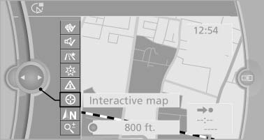
3.  "Interactive
map"
"Interactive
map"
Interactive map
4. Select the destination with crosshairs.
▷ To change the scale: turn the controller.
▷ To shift the map: move the controller in
the required direction.
▷ To shift the map diagonally: move the
controller in the required direction and
turn it.
See also:
Changing, maintaining, and storing the
speed
The rocker switch can be pressed while the system
is interrupted to maintain and store the current
speed. DSC Dynamic Stability Control is
switched on, if necessary.
Adapting the desired speed ...
Opening and closing: From inside
This button serves to unlock or lock doors and the trunk lid, but does not activate
the anti-theft system. The fuel filler flap remains unlocked.
Automatic lockingYou can also set the situations ...
Timeshift
Approx. one hour of the program being broadcast
on the channel currently being listened to
is stored in a buffer. Prerequisite: the signal must
be available.
The stored audio track can be playe ...