At a glance

At a glance
1 Function bar
2 Route section with traffic obstruction
3 Traffic sign for traffic obstruction
4 Planned route
5 Current location
6 Upper status field
7 Lower status field
Lines in the map
Streets and routes are displayed in different colors and styles depending on their classification.
Dashed lines represent railways and ferry connections.
Country borders are indicated by thin lines.
Traffic obstructions
Small triangles along the planned route indicate route sections with traffic obstructions, depending on the map scale. The direction of the triangles indicates the direction of the obstruction.
The traffic signs indicate the significance of the obstruction.
▷ Red traffic sign: the obstruction affects the
planned route or direction.
▷ Grey traffic sign: the obstruction does not
affect the planned route or direction.
Traffic bulletins
Planned route
After destination guidance is started, the planned route is displayed on the map.
Status fields
Show/hide: press the controller.
▷ Upper status field: time, telephone, and entertainment
details.
▷ Lower status field: symbol for active destination
guidance, status of traffic bulletins,
time of arrival, and distance to destination.
Function bar
The following functions are available in the function bar:
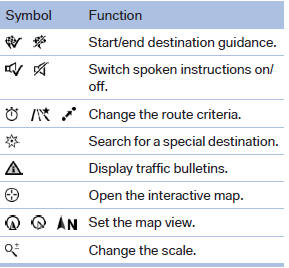
To change to the function bar, move the controller to the left.
See also:
Malfunction
The cooler cannot be switched on or switches
off, e.g., when the cooling system overheats or
if the battery voltage is low. One of the LEDs
flashes.
Remedy the problem
1. If necessary, allow t ...
Displaying messages
1. "Office"
2. "Messages"
A symbol identifies the type of message.
...
Rear seat heating
Rear seat heating
Switching on
Press the button
once for each temperature
level.
The maximum temperature is reached when
three LEDs are lit.
If the drive is continued within approx. 15 mi ...